
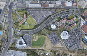
At AEC Technology, we take pride in offering advanced Digital Photogrammetry services. Our ability to generate 3D models from simple photographs, regardless of the complexity of real-world conditions, streamlines decision-making in design, construction, and operations for infrastructure and building projects.
We take Digital Photogrammetry to new heights through our cutting-edge technology. Our ability to generate 3D models from simple photographs, regardless of the complexity of real-world conditions, provides a solid context for decision-making in design, construction, and operations. We harness the georeferenced accuracy of images captured by drones to deliver a wide range of reliable results in record time, including 3D models, orthophotos, and various types of digital models.
Utilize 3D models generated from photogrammetry to enhance the planning and visualization of architectural projects.
Utilize 3D models and orthophotos to monitor and manage the construction of roads, bridges, and other projects.
Generate digital elevation and surface models for mapping terrain and assessing changes in the landscape.
Create digital terrain and surface models to analyze land and plan infrastructure projects.
Apply digital photogrammetry to visualize and analyze the impact of new developments on the urban environment.
Utilize 3D models and orthophotos to inspect and plan the location of energy facilities, such as wind farms and solar plants.
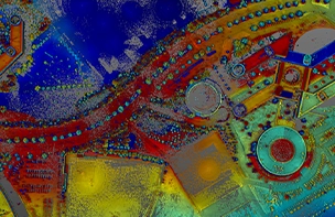
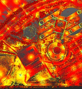
Photogrammetry enables the creation of accurate and detailed 3D models, ensuring precise measurements and a faithful representation of reality.
The data capture through images streamlines the surveying and modeling process, reducing the time needed to gather essential information.
The generated 3D models provide a comprehensive view of the project from different angles, making decision-making and communication with teams easier.
The automation of model creation minimizes human errors, improving the quality and accuracy of information.
Photogrammetry allows for the evaluation of designs and adjustments in a virtual environment before construction, saving resources and avoiding rework.
The generated models are a valuable source of information for documenting the construction process and the final state of the project.
Digital Photogrammetry is a powerful tool that helps improve efficiency in construction. By providing detailed and accurate information of the construction site, it allows professionals in the industry to identify potential issues and solutions before starting construction, coordinate the efforts of construction teams, and work more efficiently. Additionally, it enables better decision-making in project planning and design, which can help reduce costs and construction timelines.
At AEC Technology, we take pride in offering advanced Digital Photogrammetry services. Our ability to generate 3D models from simple photographs, regardless of the complexity of real-world conditions, streamlines decision-making in design, construction, and operations for infrastructure and building projects.
We take Digital Photogrammetry to new heights through our cutting-edge technology. Our ability to generate 3D models from simple photographs, regardless of the complexity of real-world conditions, provides a solid context for decision-making in design, construction, and operations. We harness the georeferenced accuracy of images captured by drones to deliver a wide range of reliable results in record time, including 3D models, orthophotos, and various types of digital models.
Utilize 3D models generated from photogrammetry to enhance the planning and visualization of architectural projects.
Utilize 3D models and orthophotos to monitor and manage the construction of roads, bridges, and other projects.
Generate digital elevation and surface models for mapping terrain and assessing changes in the landscape.
Create digital terrain and surface models to analyze land and plan infrastructure projects.
Apply digital photogrammetry to visualize and analyze the impact of new developments on the urban environment.
Utilize 3D models and orthophotos to inspect and plan the location of energy facilities, such as wind farms and solar plants.
Photogrammetry enables the creation of accurate and detailed 3D models, ensuring precise measurements and a faithful representation of reality.
The data capture through images streamlines the surveying and modeling process, reducing the time needed to gather essential information.
The generated 3D models provide a comprehensive view of the project from different angles, making decision-making and communication with teams easier.
The automation of model creation minimizes human errors, improving the quality and accuracy of information.
Photogrammetry allows for the evaluation of designs and adjustments in a virtual environment before construction, saving resources and avoiding rework.
The generated models are a valuable source of information for documenting the construction process and the final state of the project.
Digital Photogrammetry is a powerful tool that helps improve efficiency in construction. By providing detailed and accurate information of the construction site, it allows professionals in the industry to identify potential issues and solutions before starting construction, coordinate the efforts of construction teams, and work more efficiently. Additionally, it enables better decision-making in project planning and design, which can help reduce costs and construction timelines.